Agricultural Sites of Enslavement In Montgomery County: Farms or Plantations?
- Aug 6, 2025
- 24 min read
ANALYSIS AND OPINION
By Knight A. Kiplinger
Board Chair, Historic Medley District
Poolesville, Maryland

All of us who care about telling our county’s complex history with completeness and accuracy are very excited about the new initiative of the Montgomery County Lynching Memorial Project (MoCoLMP) to create a database and maps that tell a fuller story of slavery in Montgomery County.
One of its goals: to record the names of everyone involved, both slaveholders and the people they enslaved. It’s going to be a herculean task, full of research challenges, but well worth the effort.
For the first time, we all hope, it will be possible to confer a higher degree of humanity—and fuller names—to many of the too-long-faceless African-Americans who toiled in bondage, with courage and resourcefulness.
At the same time, this project will help show the many different kinds of county residents who held others in bondage. They were men and women, householders with an enslaved cook/laundress or stable worker; millowners, blacksmiths, building contractors and other small business owners; farmers on small spreads, with one or a few enslaved field workers, sometimes working alongside their owners and his family; proprietors of large farms with hundreds of acres and a few dozen enslaved field hands, sometimes managed by an overseer; slaveholders who leased their workers to others to employ, with payments to the enslavers; and some absentee landowners who enslaved their workforce but lived elsewhere, not always reflected in Census records.
Some enslavers were obscure private citizens, and some were prominent in the public life of the county before and after the Civil War, as business and civic leaders, elected local and national officeholders, judges, and founders of churches, schools and social organizations. Some were unabashed defenders of the institution of slavery, and some had deep misgivings about it, leading them to free their enslaved peoples in their lifetimes or in their wills, before Maryland emancipation in late 1864.
As board chair of Historic Medley District, the preservation and history education organization of Western Montgomery County (MoCo), I am committed to assisting in every way we can, by pointing Project researchers and writers toward archival resources and sharing our deep personal and institutional knowledge of western MoCo history.
First, the matter of what to call the various places where Blacks were enslaved in our county:
Classifying Places of Enslavement
Some of the early writings on the MoCoLMP web site refer to various locales of enslavement, such as “working in homes or out on plantations.” These two categories are too limiting, in my view, leaving out many kinds of locales that are neither small-town households nor agricultural places.
Describing all antebellum MoCo farms as “plantations” makes no distinction between farms of widely varying size, business models (whether products sold into commercial markets or consumer locally), kinds of crops and livestock grown, numbers of enslaved workers laboring there, and grandeur of the landowner’s home.
Some MoCo farms of this period might qualify, by broadly accepted definitions, to be defined as plantations, but probably very few. (See detailed discussion below.)
Sites of Enslavement (SOEs)
Tony Cohen, of Button Farm in Germantown, suggests that the Project classify all these locales as Sites of Enslavement (SOE), which allows them to be further classified by type. I strongly endorse this idea, for its breadth and flexibility for further definition and classification. Sites of Enslavement (SOEs) should include the following:
Agricultural operations—large, small and in between—ranging from just a few acres to hundreds.
Individual households—in such towns as Rockville, Poolesville, Clarksburg, Darcy’s Post Office (Bethesda), Gaithersburg and others—without much land, where enslaved workers did housework (cooking and laundry), childcare, and odd jobs, or were hired out to work in a nearby business or farm owned by others;
Non-agricultural businesses, such as mills (grist and lumber), quarries, blacksmith shops, construction firms, etc. Some of these might have been part of agricultural operations, but some were independent businesses whose owners used enslaved labor, who either lived on site or nearby. (This will make pinpointing the exact location of enslavement sometimes very tricky.)
Properties, whether farms or households, where enslaved workers were owned but didn’t work on site, but were instead hired out to others who needed labor.
Definition of Plantations in America
The Project creating its own, internally consistent nomenclature and definitions would be a useful part of this undertaking.
To properly categorize agricultural SOEs, I recommend studying the scholarly literature on 19th century farms and plantations in America, to adopt definitions appropriate to our county.
In scholarship on plantations, there seems to have has emerged a loose academic consensus on these characteristics of plantations (National Humanities Center Toolbox Library; “Enslavement;” Plantation):
Size in acres: 500 to 1,000 or more acres. (Some definitions start the acreage minimum at 200 or so.)
Number of enslaved people of all ages, not just adult workers: More than 20, usually managed by an overseer, rather than the farm owner.
Agricultural products and market: A single cash crop raised for sale into a national or global market, rather than consumed locally—that is, a “monoculture” of commodities like tobacco, rice, indigo or sugar and cotton.
Grandeur of the owner’s residence: A large, elegant home on the property, made possible by the value of the plantation’s crops produced by the labor of the enslaved workforce.
In the online resource above, it is noted that, in the American South, that “although most slaves lived on small farms with fewer than 10 slaves, the large plantation with hundreds of slaves has come to define our image of the antebellum South.” They continue: “Keep in mind that only 12% of slaveholders [in America] held ‘planter status’ by owning 20 or more slaves” (per the 1860 Census). “Of the 46,300 American plantations (estates with 20 or more slaves) in 1860, 45% had between 20 and 30.” Only 13 plantations anywhere in the South held between 500 and 1,000 enslaved people, and just one plantation—a South Caroline rice plantation—had more than 1,000, it says.
Popular conceptions of plantations
In describing a property as a plantation in modern texts, we should be mindful of the popular image of a plantation, which is rooted in portrayals in novels and movies. (Think the O’Hara family’s Tara and the Wilkes plantation, Twelve Oaks, in the film Gone with the Wind.)
The factual bases for this popular image are the very small number of famous plantations created in two distinct periods and places of wealth-creation in Southern American agriculture:
Early to mid-18th century Tidewater Virginia and South Carolina, especially along the James River and the Ashley/Cooper rivers around Charleston. On the James, such plantations as Westover and Carter’s Grove, and around Charleston, Drayton Hall, Boone Hall, Hampton and Magnolia plantations.
In the mid-19thcentury (1830s through 1860) in the Deep South, from Tennessee and Kentucky down to the Gulf Coast, Georgia and even northern Florida. This was the Cotton Kingdom, whose vast wealth, based on enslaved labor and northern capital, enabled the planters to build larger, more lavish homes—often with neoclassical columned porticos—than ever seen before in America. One of the most notable of these is President Andrew Jackson’s plantation near Nashville, the Hermitage.
Plantations in Maryland
It might be overly restrictive to require that a large agricultural estate meet all these four standards to be defined as a plantation, but certainly two or three should be met.
So, by this standard, were there plantations somewhere in Maryland in the 18th and 19th centuries? Yes—many in Southern Maryland, on the Eastern and Western shores of the Chesapeake Bay, and a few north and west of Baltimore City, in Baltimore, Howard and Frederick counties.
All were rooted in the tobacco-exporting economy of Maryland in the 18th century, dwindling but surviving deep into the early 19th century in South Maryland, even as it faded out in central Maryland (i.e., Montgomery County).
In Wikipedia entries for plantation—which are peer-written and -edited by scholars and lay readers—it says:
“Before about 1860, ‘plantation’ was the usual term for a farm of any size in the southern parts of British North America, with ‘farm’ becoming the usual term [for agricultural operations] ‘from about Maryland northward.’” (Wikipedia.org, Plantation) Does this mean to include or exclude Maryland? Not clear. Maryland is the first state south of the Mason-Dixon Line, its border with Pennsylvania and Delaware and the informal doorstep of the American South. But Maryland, the quintessential border state, did not join the Confederacy of southern states. It remained in the Union—but with its slavery intact, until the abolition of Maryland slavery by a new state constitution in 1864 (which the vast majority of MoCo voters—white males—voted against).
Tobacco exports in 18th century Maryland generated great wealth. This made possible the creation of large plantations in Tidewater Maryland—southern Maryland as far north as today’s D.C., in St. Mary’s, Charles and Prince George’s counties; north of Baltimore, especially in Baltimore and Cecil counties; and in the southern parts of Frederick and Howard counties. The owners often built large, formal homes, some of which would qualify as plantations in the modern, popular sense of the word. The greatest of these were Hampton, the Ridgely family’s 25,000-acre plantation near today’s Towson, Md. (now a public historic site), and Doughoregan Manor (built 1727, greatly enlarged in 1832), the Charles Carroll family’s 10,000-acre plantation near Ellicott City, Md. (a 900-acre core of which is still in the Carroll family today).
Of special interest to the study of slavery in Montgomery County should be Carrollton Manor, the estate of the Charles Carroll family that lay in Frederick County immediately west of Montgomery County’s western boundary along the Potomac River, with 17,000 acres (early 19th century) encompassing today’s towns of Buckeystown, Adamstown, and Point of Rocks. The 1820 Federal-style home (formal but not particularly large for a man of his wealth) that Carroll erected in 1820, but never lived at full time, is called Tuscarora, still the name of a nearby community. Like many large absentee landowners in Maryland, Carroll probably leased large portions of his vast estate to others, and it may be difficult to determine the number of enslaved workers, toiling on his lands, that he owned directly.
Closer to today’s Washington, other elegant Maryland plantations included Belair (in Bowie, Md.) and Riversdale (in today’s Riverdale/Hyattsville, vicinity), both in nearby Prince George’s County, once the locus of many large tobacco plantations.
It should be noted that some of the most elegant town homes in Annapolis were built by large landowners who didn’t live on plantations themselves, but derived vast wealth from their agricultural properties around Maryland, worked by bondsmen and managed by overseers.
Among the biggest landowners in Montgomery County before the Revolution were Daniel Dulany and his sons, slaveholding Tories who forfeited their lands when they sailed to England after the war. Dulany lived luxuriously in Annapolis and never built a plantation house on his MoCo lands.
Much of Dulany’s lands in western MoCo were acquired at Tory auctions in 1781 by Robert Peter, the Scottish-American, tobacco-exporting first mayor of Georgetown (Maryland, at the time), and patriarch of the multi-generationally Peter family of Darnestown and Seneca. In the early 19th century, Peter’s MoCo landholdings (some 2,500 acres, mostly between Darnestown and Poolesville) and his enslaved people were divided among his sons, including Thomas and George, after his death in 1802, gradually reducing the average size of the Peter family farms in the vicinity of Poolesville, Darnestown and Seneca.
MoCo agricultural sites: Farms or Plantations?
Based on the four key traits of a plantation (acreage, number of enslaved workers, single-crop market culture, and size/elegance of the planter’s home), there were very few properties in Montgomery County in the 18th and early-to-mid 19th century that could accurately be called plantations. There are properties that might meet one or two criteria, and some maybe three or four, but rarely all four.
A more-accurate judgment can only emerge from determining the exact acreage of a given landowner on a particular agricultural site, and then matching that site with Census records for the period in question (say, 1860), to show the number of enslaved workers on that site and their likely ownership. This, generally, is the goal of the survey of enslaved and enslavers now being undertaken.
For the size of farms, researchers must use recorded deeds and probate records, since there weren’t property assessments and taxes like today’s. Susan Cooke Soderberg, in her fine new biography of Josiah Henson, writes “[in 1800] most farms in Montgomery County were under 50 acres, and much of the land was still covered in forest.” (Soderberg)
The sizes of farms were constantly fluctuating, as ambitious landowners acquired neighboring tracts, struggling farmers sold land, and properties were divided among heirs after the death of a major landowner.
Number of enslaved workers on a property
A key trait of a plantation is a slaveholding of adult workers large enough to work more than 200 acres, a number that scholars estimate at more than 20 (depending on the crops and livestock grown).
Based on the MoCo Census for 1860, before the dawn of the Civil War, analysis to date suggests that the 770 slaveholders held 5,421 people in bondage, averaging just seven enslaved people of all ages per site of enslavement. Recent research by this Project is boosting this number of identified county enslavers, which now stands at 816.
Some of these SOEs were households in small towns, some were non-farm businesses, and many were farms of varying sizes. This recent Project research also suggests that the majority of SOEs in the County, 56%, held five or fewer people in bondage.
How many of these SOEs held enough enslaved peoples to qualify as plantations, with more than 20? Census data shows just 47, or 6% of the total. (Those 47 break down like this: 32 enslaved 21 to 30 people; 12 held 31 to 40 in bondage, and only five held 41 or more.)
So the screen for the plantation definition should focus on locating those 47 large SOEs throughout the county in 1860.
Even if an agricultural SOE in MoCo makes the plantation cut on acreage and number of enslaved people, there is the matter of its business model—kinds of crops grown and where sold.
Agriculture in Antebellum MoCo
Our understanding of the County’s farm economy in the 18th and early 19th century should start with excellent discussions in numerous readily articles and books, including the superb brochure, “African American Heritage,” published by Heritage Montgomery. The following highly knowledgeable local authorities are listed as “contributing editors and content experts”: Anthony (Tony) Cohen, Eileen McGuckian, Shirl Spicer and Joy Turner. (Cohen et al.)
I also highly recommend Eileen McGuckian’s classic monograph, “Emancipation in Montgomery County Md.” (McGuckian, p. 9). It’s a lucid overview of slavery and emancipation in the county from its settlement through 1864.
Also invaluable to understanding agriculture and slavery in MoCo in this period are two superb biographies of Josiah Henson, the remarkable enslaved man who escaped bondage in Montgomery County in 1830, on the Riley farm in today’s North Bethesda, to become the leader of a black community of freedmen in Canada, published author, preacher, abolitionist orator, and celebrity in America and Great Britain. One biography is by Jamie Ferguson Kuhns, the other a recent biography by Susan Cooke Soderberg.
Small-scale agriculture in MoCo
It is clear from all these sources that agriculture in MoCo in this period differed greatly from the plantation economy of the Deep South. It was generally small-scale (on smaller farms); based on a diversity of crops consumed on site or sold locally, rather than a single cash commodity; and produced by a mixed labor force of farm families and enslaved workers—often fewer than five, often working alongside the owner and his family.
The Heritage Montgomery brochure says [italics are mine]: “Montgomery County was founded in the mid-1700s with a diversified economy based on small-scale farming and manufacturing. Enslaved people labored here, but in smaller numbers than in counties surrounding the Chesapeake Bay that were involved in large-scale transcontinental trade…. As farming changed from labor-intensive tobacco to grains [in the early 1800s], the use of enslaved labor diminished here, while the demand for workers to drive the plantation economy of the South increased. In the decades leading up to the Civil War, many Montgomery County slaves were shipped off to Mobile, Natchez and New Orleans. Here they were sold to the formidable indigo, cane, rice and cotton plantations of the Gulf Coast states.” (Cohen et al.)
Soderberg writes: “As the county moved into the 19th century, it shifted further away from a slave society and toward a more diversified society of small farms, millers, providers of services such as taverns and inns, blacksmiths, wheelwrights, and produce sellers along the well-traveled roads.” (Soderberg) (It should be noted, of course, that many of these small businesses also used enslaved labor, even if just one or two workers.)
Note these distinctions made between farms and plantations, a difference that is made in many references throughout the 19th and early 20th centuries, in both popular and academic writings. In Maryland, it’s a distinction between the smaller, diversified farms of “western Maryland”—including Montgomery and Frederick counties—and the older, larger farms of Tidewater Maryland, whose sandy soils in large, flat fields were cultivated in tobacco beginning in the late 17th century and continuing through the 19th century, long after tobacco (which had depleted the soil) had given way to grains in Montgomery County.
The agricultural economy of Montgomery County—a later-settled part of “western Maryland”—was never based solely on tobacco, and less so as the soil was depleted and grains (wheat, oats, barley, rye) rose in prominence. In 1790 (according to MacMaster and Hiebert’s 1976 county history A Grateful Remembrance, Maryland produced about 25% of the tobacco exported from the U.S., and MoCo accounted for only 20% of Maryland’s total—that is, just 5% of the U.S. export volume. By 1830, Maryland’s share of the national tobacco crop had fallen to only 10%, and MoCo’s probably declined similarly, as farms had shifted to grains and vegetables long before.
Contemporary descriptions of MoCo Farms
The agricultural properties of our county were typically called “farms” in the 18th and 19th centuries, not just by their owners, but by contemporary observers. This does not, by itself, require that modern writers do the same, but knowing past usage helps us avoid the pitfall of “presentism”—judging the past only through the lens of modern sensibilities and attitudes.
We’re all aware that even today, self-effacing (or falsely modest) property owners sometimes downplay the size or elegance of their substantial homes, rarely calling them a “mansion” or “estate.” (It’s an age-old habit; for example, some plutocrats of the Gilded Age referred to their huge Newport, R.I., palaces as “cottages.”)
Nonetheless, it is clear from numerous advertisements in early 19th century Montgomery County newspapers—in which land, goods and enslaved workers were offered for sale—that rural properties were most often described as “farms,” by their owners and others.
An 1802 ad for a male donkey, placed by Robert Peter, said the animal can be inspected “at my farm near the mouth of the Seneca Creek.” His son, Thomas Peter of Tudor Place and Seneca, placed a legal notice in 1826 stating that he was conveying to his son, John P. C. Peter “500 acres known as my ‘Seneca Farm’”—part of the farm, then called Oakland, where John built his home, Montevideo, in 1830.
The word “plantation” does appear, but infrequently, in 18th and 19th century contemporary writings—deeds, wills, etc.—in Montgomery County. One example would be the 1786 will of Samuel Magruder, whose 1767 stone home, called Stoneyhurst, still sits hidden on a small lot off River Road and Seven Locks Road, just west of the Beltway, in today’s Bethesda. (In the 20th century, it was the longtime home of Lilly Moore Stone, a founder of the Montgomery County Historical Society.) In his will, Magruder bequeathed to his wife his “plantation dwelling,” its surrounding 200 or so acres, and several enslaved people he named. Whether others at the time or in later years viewed Mr. Magruder’s farm as a plantation, he apparently did.
Of the more than 100 large 18th century MoCo land patents listed in Thomas Scharf’s exhaustive History of Western Maryland (1882), only one patent includes the word “plantation” in its title—the “Middle Plantation” (1724), 727 acres patented by Daniel Dulany, land near the mouth of Seneca Creek. But Dulany didn’t have a working plantation there, as the term came to be used over the next hundred years.
The word “plantation” in English usage originally meant any piece of land cleared of its virgin forests for the planting of crops. It described the natural condition of the property—ready for planting something—rather than physical improvements on the property…homes, barns, slave quarters, etc. When the “Middle Plantation” land patent was granted to Dulany, there was probably nothing on the land except dense forests or recently cleared land ready to plant.
Slavery by the numbers in MoCo
Montgomery County was settled in the mid-to-late 18th century mostly from east to west, by English- and Scottish-American farmers moving inland from Tidewater Maryland, especially Prince George’s and Anne Arundel counties, in search of fertile and less-expensive land for tobacco. Some of them brought their enslaved workers with them, introducing slavery to this central Maryland county. By the late 18th century, slavery was common (if relatively small-scale) throughout the county, with the notable exception of the Quaker community around Sandy Spring1.
Slaveholders in Montgomery County were always a very small minority of the total population of the county in the late 18th and 19th century, when most people lived on small farms which they often worked with their own family members. Enslaved labor was not the dominant kind of labor in the county, because an estimated two-thirds of the county’s households and small businesses and farms did not own slaves.
The first census of 1790 listed 929 slaveholders in the county, in a white population of 11,679. They enslaved, on average, seven people each. “Only 36 planters in Montgomery County owned 20 or more slaves,” writes Soderberg, “and 80% of the enslavers owned fewer than 10 slaves, with one-third of those only one or two.” (Soderberg)
Sixty years later, in the census of 1860, the number of enslavers had fallen 17% to 770. On the eve of the Civil War, here are the comparable numbers showing the continuing small scale of slavery in the county: The 770 enslavers owned the same average number of people—seven—as in 1790. Of those enslavers, 56% held one to five people in bondage. As MacMaster and Hiebert note in their 1976 county history, A Grateful Remembrance (p. 152), “The pattern of owning one or very few slaves was just as common in 1860 as in 1790.” The largest slaveholders in 1790 seemed to have been Richard Thomas and a Carroll, with some 50 enslaved workers each.
Interestingly, free Blacks had risen to 8% of the county’s total population by 1860, despite requirements of manumitted slaves to move out of state and draconian restrictions on the lives of freed Blacks.
An interesting aspect of farming in this era, worthy of additional study, would involve tallying the location and size of county landholdings by the free Black communities. Some slaves manumitted by their enslavers were given property at the same time, and MacMaster and Hiebert mention (but do not identify) “one Montgomery County master who turned over 200 acres to a freed slave.” (McMaster and Heibert, p. 18)
By 1860, they write, there were 51 Black landowners in the county, “many with very small holdings,” (McMaster and Heibert, p. 156) but they totaled 17,142 acres. Most of them were small farms in the vicinity of the Sandy Spring Quaker community.
Declining population and agricultural vitality in MoCo
Population declined in the Middle Atlantic (Virginia, Delaware and Maryland, including Montgomery County), as agriculture slumped from wearing out the fertility of the soil, and young white men went south and west (often to Kentucky and Tennesse) to seek their fortunes, sometimes taking enslaved workers with them. Farmers in the mid-Atlantic, including Maryland and Virginia, sold enslaved workers south to the booming Cotton Kingdom.
MoCo suffered a startling loss of population in the 10 years from the 1790 Census (18,000) to a low of 15,000 in 1800, and it was still just a little over 15,000 three decades later, in 1840.
The Black population of the county (enslaved and free) fell from a peak of 8,249 in 1810 to a low of 6,425 in 1850. The factors were many: the “sale South” of surplus enslaved farm workers by struggling county farmers; the 1831 Maryland legislative ban on bringing any more slaves into the state from anywhere else; and restrictions on free Blacks from other states settling in Maryland. Similarly, slaveholders who freed their enslaved workers were required after 1835 to send them out of state.
Despite this, due to the high white outmigration in the 1830s, Blacks rose as a share of the total county population to 43% in 1840. (Attempts by whites to entice Maryland slaves to emigrate to Liberia were highly unsuccessful, and there is no record of any enslaved peoples from MoCo joining the African “colonization” movement.)
In most of the county, the soil was so poor that, in the words of Scharf’s history (1882), “Montgomery land had become a synonym for poverty.” It was only the introduction of fertilizer in the 1840s (both imported Peruvian guano and powered lime from crushed burnt limestone)—soil enrichment techniques learned from Quakers in Loudon County (Va.) and Sandy Spring (Md.).
Historian Roger Brooke Farquhar wrote in 1952: “Montgomery County suffered from too-depleted soil more than any other county in the state, and by 1840 it was an area of tired land, old fields, and broken fences, and many of houses were in disrepair.” He concluded: “Much of the county, so rich today, had become poverty-stricken.” It was no wonder that many slaveholders in Montgomery County were tempted to, and actually did, sell their enslaved workers south to the Cotton Kingdom, where the economy was booming.
Farquhar credits the introduction of Guano fertilizer by local Quakers in 1844, and the resulting surge in corn and wheat yields, with a miraculous turnaround in the MoCo economy in the 1850s—aided by global wheat demand boosted by the Crimean War in Europe. “The decade between 1850 and 1860 was one of unrivaled prosperity for the people,” he wrote. (Today, we would specify the “white people” of the county, and perhaps some of the free Blacks too.)
A grain-based economy and livestock required fewer workers, so Maryland continued to sell their surplus enslaved labor force to the South and West, where labor-intensive tobacco and cotton were booming.
In the Richard K. MacMaster and Ray Eldon Hiebert history, A Grateful Remembrance: The Story of Montgomery County, Maryland 1776-1976, they offer this distinction between the popular image of the southern plantation and farms in Montgomery County. Here are those comments, quoted by Wendy Kails (curator of Tudor Place in Georgetown) in her 2016 article on Oakland, the Peter family’s farm in Seneca, Md. (Kails):
----------------------------------------

MacMaster and Heibert continue their description of mid-18th century MoCo farms: “The average land holding in the area (the future Montgomery County) in 1752 was well under 200 acres, and many a landowner had no more than 20 acres to his name. Men with ample acreage lived in a simpler style here in Western Maryland than in Tidewater.” (McMaster and Heibert)
“John Cooke, who left more than 4,000 acres of Montgomery County land to his heirs in 1778, lived in a small house much like the one described as typical of the county,” they wrote. “James Brooke, the largest landowner in the county, paid a builder 143 pounds for building the first Brooke Grove in 1766, the same year James Brice paid more than 4,000 pounds for his Annapolis townhouse. Today, Montgomery County is different from its neighboring counties in Southern and Western Maryland. The nature of the land and the way it was developed had set those differences by 1750.” (McMaster and Heibert)
Montgomery County was split off of Frederick County in 1776, and by the late 18th century, some landowners had acquired enough land to create contiguous farms of 500 to 1,000 acres. Robert Peter of Georgetown, Md., was a heavy buyer of lands confiscated from the Tories in auctions in 1780-81, amassing some 2,500 acres in western MoCo, from east of Seneca Creek to the Sugarlands south and west of Poolesville, that would be divided among his sons in the early 19th century. (The Sugarland locale, still the site of an historic African-American community, probably derived its name in the early 18th century from the fertility of the flat, low-lying lands along the Potomac and from the forests of sugar maples.)
Homes of the Rural Wealthy in MoCo
The fourth and final characteristic of a plantation—besides acreage, size of its enslaved labor force, and monoculture (tobacco, rice, sugar, cotton)—is a central owner’s residence of considerable size and elegance.
As with the other three standards, MoCo has few if any historic farms whose owners’ residences meet the popular or academic standard of a plantation house.
The county has no five-part Palladian Georgian mansions like Riversdale in Prince George’s County, or the James River plantations, or James Madison’s Montpelier, Washington’s Mount Vernon, or Jefferson’s Monticello, all in Virginia, or Oatlands in nearby Leesburg (Loudon County, Va).
The indispensable source for the architecture and family histories of MoCo’s finest homes of the pre-Civil War era is Historic Montgomery County, Maryland: Old Homes and History, first published in 1952 (and revised several times thereafter) by Roger Brooke Farquhar, a prominent member of the Quaker community in Sandy Spring. Like all histories, it is not without some errors of fact, but it is a remarkable work when research in public records was arduous.
Its photos and descriptions of every historic home in MoCo (including in some cases, the original acreage and slaveholding) enable a modern researcher to assess the simplicity or elegance of every property, and to decide for oneself whether it warrants being called a plantation.
Let it be said, at the onset, that Farquhar’s own characterization of these homes is highly subjective and sometimes quixotic, without any systematic framework.
He calls homes of widely varying size and grandeur, variously, a “homestead,” “estate,” “lovely country home,” “manor house,” “brick house,” and “mansion,” and “plantation.”

To my eye, as a student of architectural history, very few historic homes in MoCo make the cut of excellence and grandeur befitting a plantation house. This short list would include Hayes (1762), off Connecticut Avenue in today’s Chevy Chase, an elegant Georgian brick home that was the center of the Dunlop family’s 700-acre estate. Another would be Woodlawn Manor, the late 18th-century brick home of the Richard Thomas family in Olney/Sandy Spring, now a county Black history historical site. (The Thomas family were Quakers and slaveholders, but manumitted many of enslaved workers at various times, to comply with the Quaker meeting’s hardening line against slavery.)
Some historical homes with a plantation-like grandeur today—like Aix La Chapelle in Barnesville—started as more-modest brick homes before additions in the early 20th century that increased their grandeur.
In researching estates in MoCo, one should also beware of 1920s reproduction mansions in the Classical and Colonial Revival styles, such as Glenview Mansion, the Rockville Civic Center today. Today’s Glenview was built in 1926, totally enveloping the earlier, smaller (1838) Glen View home of Judge Richard Bowie; with some 500 acres worked by 24 enslaved people, the original Glen View (surrounded by suburban neighborhoods today) would certainly have met most of the tests of being a plantation.
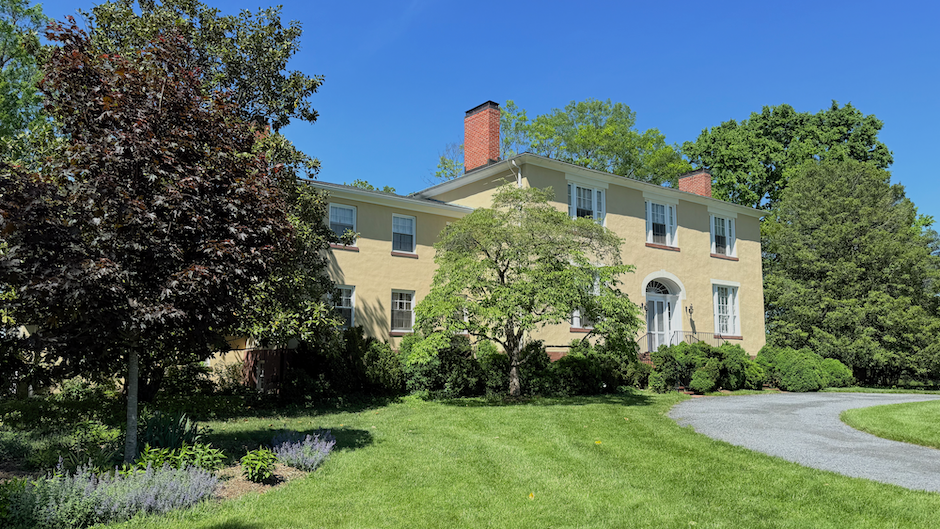
One of the most-formal Federal-period residences in the county, Montevideo (c. 1830), is a scaled-down replica of the Thomas Peter family’s mansion, Tudor Place (1812), in Georgetown. Like Tudor Place, which has walls of stucco over brick, Montevideo has stuccoed stone walls, with the stucco originally scored to look like cut stone—a common practice in the Federal era, but a unique feature in MoCo historic homes.
With a surrounding farm of nearly 1,000 acres at its peak in the early 1840s, worked by 15 to 20 enslaved people at various times, Montevideo would qualify as a plantation by all standards except having a monoculture—it grew a variety of crops and livestock for the Peter family in Georgetown and sale at public markets in D.C.
While Farquhar called Montevideo a “ponderous manor house” in 1952—notable for its high ceilings, large three-part windows and elegant interior trim—it was not a particularly large residence for its time, especially given the wealth of its builder, John Parke Custis Peter (1799-1847). It had three public rooms (with front and back halls) on the first floor, with four bedrooms on the second floor (for a couple with eight children). Some enslaved household workers probably lived in the basement near the winter kitchen, the farm workers lived in a large red sandstone residence (quarters) a quarter-mile away, next to the overseer/manager’s home (both still standing today) near River Road.
“Plantations” with very simple homes
The vast majority of homes in Farquhar’s directory are handsome but not especially large and ornate brick or stone homes, many of them built in the years of the county’s agricultural decline, 1800-1840. (Many have been renovated or expanded in the 20th century, so some look more imposing today.) These include such notable properties as Milton (in Bethesda near Western Avenue), Annington, Inverness, Needwood, Stoney Castle, Chiswell’s Inheritance, and Stoneyhurst (in Bethesda), to name a few.
To illustrate how modest were some owners’ residences on early MoCo farms of considerable size, one has only to look at early drawings of Brooke Grove, the 1760s-70s residence of Roger Brooke IV and his son, Roger V, who at one time owned almost 15,000 acres of Sandy Spring. It was a very rustic frontier home of logs, stone and plaster. Author Farquhar (a descendant) calls Brooke Grove a “homestead,” and he’s right. A plantation? No. Yes, it was immense in size, but not a plantation by any other trait. Notably, the Brookes were Quakers who never held anyone in bondage, Farquhar wrote. Their huge estate was worked by tenant farmers and wage-earners.
George Peter—one of Robert Peter’s sons, an inheritor of a fifth of his acreage in MoCo, and a MoCo member of Congress in the 18-teens and 1820s—had an elegant home in Georgetown, but lived much of the year at a simple farmhouse, called Montanverde, that he built around 1812 near Seneca Creek in Darnestown. He is thought to have owned numerous farms around western MoCo, as well as a few dozen enslaved people, making him one of the county’s largest enslavers. But neither Montanverde nor his other farms could be accurately called plantations.
The Isaac Riley Farm
No historic property in MoCo illustrates the dilemma of defining a plantation better than the Isaac Riley family farm, on Old Georgetown Road in today’s North Bethesda (today’s Josiah Henson Museum and Park).
This farm, which once encompassed more than 500 acres on the historic road between Georgetown and Frederick, Md., was where Henson lived and toiled an enslaved man and overseer of his fellow workers. It was the setting of much of the Rev. Henson’s first autobiography, in 1849. That book was a key source for plot lines and characters in Harriet Beecher Stowe’s sensational abolitionist book, Uncle Tom’s Cabin, the best-selling novel of the entire 19th century, worldwide.
In several passages, Henson refers to slave-holding properties variously as a “farm,” an “estate,” and “a plantation.”
“I was born on a farm in Charles County, Maryland,” he wrote. On the death of the owner, it was “necessary to sell “the estate and the slaves,” he writes. His mother and he were later bought by Isaac Riley in Montgomery County, Md., where he described his life on “my master’s plantation” there. Elsewhere in his memoir, Henson refers to “R.’s [Riley’s] estate,” and “any estate in the neighborhood.” (Henson)
The Riley farm, on today’s Old Georgetown Road in North Bethesda, was hardly a formal plantation in the popular or even academic sense. Interestingly, it didn’t seem that the Riley family or anyone else ever gave this farm a distinctive and picturesque name, like most other large properties (and even small ones) in antebellum Montgomery County.
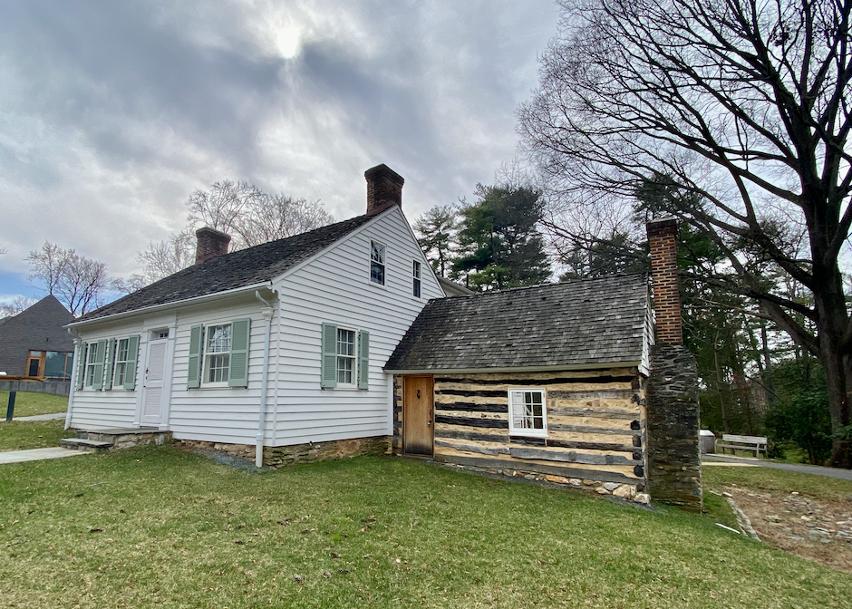
The “big house,” as the master’s house was often called, was in this case anything but big or impressive. In a dilapidated state in a 1919 photograph, the Isaac Riley home, built circa 1800-1815, was an extremely modest one-and- a-half story wooden clapboard building. It had only four rooms—two on the first floor and two in an attic with gable windows, without even the dormer windows that were common in this period; the chinked log kitchen was attached to the side.
Henson’s primary job, as a trusted enslaved man of high character and intelligence, was to oversee the other enslaved farm workers and take the vegetables, meats and other produce grown on the farm to sell “in neighboring markets of Washington and Georgetown.”
The number of enslaved workers on the Riley farm? According to Kuhn’s and Soderberg’s biographies of Henson, based on Census and tax records, there only two in 1800, rising to maybe 15 in 1810, falling to 11 in 1820 and only four in 1829. In his 1849 memoir, Henson recalls there being about 22 enslaved workers at the Riley farm in the mid-1820s, but his memory doesn’t square with archival numbers.
Significantly, by the time of the Civil War, when Riley’s widow Matilda was running the farm, the number of enslaved workers seems to have dwindled considerably. In the 1867 “Record of Slaves in Montgomery County”—the tally of slaves that owners freed after the 1864 constitutional emancipation, for which they (unsuccessfully) sought compensation from the federal government—Matilda's son Benjamin listed eight slaves on the Riley farm.
Perhaps because of the notoriety of the Isaac Riley farm from Henson’s memoir and the huge success of Stowe’s novel, the Riley property has long been called a plantation, despite failing to meet most of the characteristics of a plantation. Hence Farquhar’s description of this simple property as a “plantation.” It was plantation only in its large acreage—not in the average number of its enslaved workers, its farm operations, or especially, the quality of its owner’s residence.
Conclusion
I hope this discussion will give some historical context to the MoCoLMP Project’s survey research, and also provide a systematic framework for classifying the many different kinds of Sites of Enslavement, ranging from households and businesses to agricultural properties of widely varying size, enslaved work forces, and architectural quality.
From this Project, I hope, there will emerge a nuanced picture of slavery in Montgomery County, based on its unique agricultural heritage, so different from other counties in Maryland and other places in the American South.
With all best wishes,
—Knight Kiplinger
Seneca, Maryland
Aug. 1, 2025
Works Cited
Cohen, Tony, et al. Crossroads & Cultures: African American Heritage. Heritage Montgomery, August 2021, https://www.heritagemontgomery.org/wp-content/uploads/2021/08/Af-Am-Brochure-FINAL-for-web.pdf. Accessed 6 August 2025.
Farquhar, Roger Brooke. Historic Montgomery County, Maryland,: Old homes and history. First ed., Roger Brooke Farquhar, 1952.
Henson, Josiah. The Life of Josiah Henson: An Inspiration for Harriet Beecher Stowe's Uncle Tom. Dover Publications, 2016.
Kails, Wendy. “Oakland: Far from the Madding Crowd.” Tudor Place, 02 April 2016, https://tudorplace.org/wp-content/uploads/2020/07/Oakland-March-2016_revised.pdf. Accessed 06 August 2025.
Kuhns, Jamie Ferguson. Sharp Flashes of Lightning Come from Black Clouds: The Life of Josiah Henson. Maryland-National Capital Park and Planning Commission, 2018.
McGuckian, Eileen. “Emancipation in Montgomery County, Maryland.” The Montgomery County Story, vol. 57, no. 2, Winter 2015, pp. 9-25. https://mchdr.montgomeryhistory.org, https://mchdr.montgomeryhistory.org/server/api/core/bitstreams/35a60914-2e20-4bcd-aa27-069c6694f55d/content. Accessed 06 August 2025.
McMaster, Richard K., and Ray Eldon Heibert. A Grateful Remembrance: The Story of Montgomery County, Maryland. Rockville, Montgomery County Government and the Montgomery County Historical Society, 1976. www.montgomeryhistory.org, https://montgomeryhistory.org/wp-content/uploads/2024/12/FINAL-MacMaster-Heibert_AGR_1976_sm.pdf. Accessed 06 August 2025.
National Humanities Center Toolbox Library. “Enslavement/Plantation.” National Humanities Center Toolbox Library: Primary Resources in U.S. History & Literature, National Humanities Center, March 2007, https://nationalhumanitiescenter.org/pds/maai/enslavement/text3/text3read.htm.
Scharf, J. Thomas. History of Western Maryland, Volume I. Wildside Press, 2024.
Soderberg, Susan Cooke. My Name Is Not Tom: The Life of the Reverend Josiah Henson. Georgetown University Press, 2025.
Wikipedia.org. “Plantation - Wikipedia.” Wikipedia, the free encyclopedia, 14 June 2025, https://en.wikipedia.org/wiki/Plantation. Accessed 6 August 2025.


As usual, Knight provides a wonderful framework to make better judgements and assessments about what history tells us. When it comes to plantations, I studied the Civil War extensively during my college years, including going to the Library of Congress to do archival research. Several things struck me about plantations as I came to see them in addition to what Knight mentions. Unlike farms or small agriculatural plots, plantations were complex, often self-sufficient communities with distinct social hierarchies. Due to limited transportation and infrastructure, and the often vast sizes of plantations in a wide area, plantations often functioned as self-contained communities, producing not only their main cash crop but also food, housing, and other necessities for the people who l…