What did freedom mean to the enslaved of Montgomery County, MD?
- Oct 7, 2025
- 8 min read
Updated: Apr 3
Learning about our historic Black communities
by Neile Whitney

I was part of the “Gone With the Wind” generation: Slavery was only in the Deep South. New England, where I grew up, had nothing to do with slavery.
Lincoln freed the slaves everywhere in January of 1863.
Urban development was necessary, and helped poor people.
But in the middle of all this misinformation, I always wondered about that enslaved person working in the fields.
What happened to them? What did freedom mean? What could they do and where could they go when they had only the skills of their hands and the courage in their hearts -- when they may not have known where to go or how to get there?

When Maryland finally freed its enslaved people in November of 1864, almost two years after the Emancipation Proclamation, farms in our county were fairly small—most less than 500 acres—so they were close enough together that word probably spread quickly.
What did freedom mean that day to an enslaved young man who only knew farm labor? What did it mean to a 40-year-old enslaved carpenter who had been rented out to neighbors for years and appreciated for his skills? What did it mean to 70-year-old Horace Mitchell, enslaved in Gaithersburg by Elijah Thompson, or 67-year-old Lucy Hall, enslaved in Germantown by William Blunt, who would have been put to work when they were 4 or 5 years old and were now old and brutally tired?

How much had the Civil War affected their ideas of freedom and their prospects for a new life? What did freedom mean to a young man home from war, perhaps with some savings in his pocket and a new understanding of the country he lived in?
What did a young enslaved mom with five children think when a friend told her she was free?
What kind of life did they imagine for themselves?


1867 Slave Statistics, Montgomery County
I wonder if 30-year-old Richard Lee, enslaved by Warren King in Beallsville, immediately put down his tools and started walking towards the B. F. White farm up the road to find his 25-year-old wife Clarissa and their children, Julia (10 years old), Noah (8), Richard, jr. (6), James (4), and their 2-year-old baby boy? Did he feel sick to his stomach, wondering how he would feed them tomorrow, since their homes and everything in them belonged to their enslavers?

We'll never be able to answer many of these questions.
But from the U.S. Census, we do know that six years later, by 1870, freedom to Mr. Lee meant he was working as a farm laborer and living next door to Clarissa’s former enslaver. Mr. Lee was living with his wife and six children, and already owned real estate worth $20. He had not yet learned to read or write, but his school-age children did.
We can wonder about the other 5,400 enslaved persons who were freed that day in our county and ask ourselves how many were able to stay where they were, paying rent and receiving small wages, and how many started walking to find family, to find work—to find a new life, somewhere, anywhere—else.

We can't answer all of these questions. But what we do know is that between 1801-1940, free, manumitted and emancipated Black people founded 140-160 communities in Montgomery County. The image above is a screenshot of a draft of MoCoLMP’s interactive map showing 140 of its historic Black communities. We’re still researching locations and information for about 20 others.
In 1768, Quakers had been instructed by their yearly meeting to free their enslaved workers, and were told they would be disowned from weekly meetings if they did not comply. By 1820, Quaker slaveholders in the county (mostly in the Sandy Spring area) had either freed their enslaved laborers or left the meeting.
These manumitted laborers founded early segregated Black communities such as Ebenezer, in Ashton, MD, founded in 1801, as well as Holly Grove, Cincinnati, Batson and others.

This map shows some of the early communities founded before the Civil War in our area, including Big Woods, begun in 1813 in Dickerson when James Spencer bought 50 acres of land. It shows later communities founded during Reconstruction post-Civil War, as well as those founded in the early 1900s as new opportunities opened up in the county.
It also shows, in the second layer, local enslavers from the Civil War era, with a pop-up of basic information, including the enslaved they claimed in the 1867 Slave Statistics. This census was recorded in the hopes that they would be repaid for the loss of their enslaved “property.”
The pop-up example on the left side of the map is of James Magruder, who lived in Germantown, and the twelve people he enslaved. Our research project is using the names found in the 1867 Slave Statistics to try to trace the persons enslaved on these properties to the people who founded our historic Black communities. So far we have located over 200 of the over 800 enslavers listed on the 1867 Slave Statistics or on the 1860 Slave Census and have connected many of them to the names of their enslaved.
In the area historically called the Medley District, communities around Poolesville included Sugarland, Martinsburg, Jerusalem, Jonesville, Texas, and Alabama. Berryville and Seneca were down near River Road. Blocktown, Bucklodge, Owensville, Sellman, Thompson’s Corner, and Turnertown are up in Boyds, Beallsville, Dickerson and Barnesville.
Some of these communities were composed mostly of immediate family, such as Owensville on Rt. 109, which consists of three tidy homes owned by family members, some of whom had been enslaved by the Brewer family over in Aix la Chapelle (ex-la-shah-PELL). Some of the communities were as large as Scotland, in Potomac, which consisted of 500 acres and about 50 families, and Emory Grove in Gaithersburg, supporting 500 people on 300 acres. Sugarland, shown in this map and pop-up detail above, sheltered 40 to 70 families over the years on 200 acres of homes, gardens, orchards, as well as a post office, a general store, a church and a school.

In the 1800s Black families consisting of about 6-10 or more members, often lived in log cabins like this on at Rock Hall, with one or two rooms and a loft above, or sometimes two rooms over two rooms. A number of freed families remained in the cabins they’d lived in when enslaved and then became sharecroppers.
Researcher Eileen McGuckian tells us in her interesting 1992 article on the history of Black builders 1865-1940, that around the turn of the century, log homes started being replaced by I-houses. These were one room deep, two rooms wide and 2 stories high. By 1920 concrete blocks had been invented and improved upon, and could be used to build relatively inexpensive, but sturdy homes for large families.
Some families built wood frame houses, two rooms over two, with central hallways. Later, these homes would often have rooms or porches added, new siding, and other additions.
Barns and pens for chickens and pigs, and space for vegetable gardens and orchards would be developed and many families, especially upcounty, were able to be largely self-sufficient. Even downcounty, smaller lots in neighborhoods like Hawkins Lane in Bethesda or Linden-Lyttonsville in Silver Spring would have vegetable gardens behind the house and open space in front where children could play and adults could socialize.
As soon as they had a roof over their heads, families who had been meeting at someone’s house for church on Sundays would start planning to buy or donate some land to build a church.


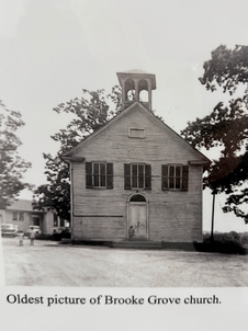


Left, descendants of Stewartown. Middle, Poplar Grove Baptist Church, Potomac. Right, Interior and photos of ancestors, Warren Church, Dickerson, MD.
Then, the community would start raising money for a church building. The church was the center of the faith community, but also the center of community social life. Most of the churches were Methodist, but some were Baptist.
Teaching children to read, write and do arithmetic was a top priority for families, so at first their homes or a new church building would be used for schools for the children until they could raise more money to build a schoolhouse.
Usually children ages 6-14 would be sent to school and by 1870, most of them could read and write according to the census. After about age 14, many would start working to help support their families. Even in the early, hopeful days of Reconstruction, most communities were segregated. Schools weren’t integrated in Montgomery County until the late 1950s.
When they weren’t working, community members enjoyed participating in literary societies, choral groups, basketball, baseball, and drill teams, and cornet bands. Emory Grove, founded in 1864, was a popular destination for Black folks in the area. Stars like Aretha Franklin, Fats Domino, Chuck Berry, and Tina Turner played the Chitlin’ Circuit at the Du-Drop Inn. There was music and dancing, and locals such as Chuck Copeland’s dad, Howard, were sometimes asked to accompany the band on drums. Children were known to sneak out of their homes when mom thought they were asleep, and wide-eyed, peek in the windows of the juke joint to listen to stars of rock-’n-roll.
Methodist camp meetings drew people to Emory Grove’s Johnson Park from as far away as Pennsylvania and New Jersey for three weeks in August, to hear preachers, eat good food, and see old friends and family. And on top of all this, Emory Grove had the first lighted baseball field in the area, where community teams competed fiercely.
The Mapping Segregation Project by Montgomery County Planning, notes that between 1890 and 1960, the white population in the county increased 1800%, while the Black population grew only 19%. “These racial population shifts were not the result of organic growth. Rather, they occurred due to the specific actions of land developers, property owners, real estate boards, and the government who used de jure and de facto segregation to limit opportunities for Black Americans by directing investments into majority white communities, prohibiting Black homeownership in those neighborhoods, and controlling the development of entire communities.”
In the 1960s and ‘70s, Emory Grove fell victim to developers and planning by the county, and was flattened. Only Emory Grove United Methodist Church and a well pump remained, as homes were razed, families displaced, and townhomes built to take their place. Some families stayed and some left.
Today, 50 years later, the community has created a redevelopment plan. Heritage Emory Grove tells us, “Street grids, pedestrian connectivity, an updated community center, and Johnson’s Local Park, along with historical programming, cultural amenities, and community gardening are all intended to help re-establish the once-familiar sense of camaraderie of the original community.”
Because of the Agricultural Reserve, some areas upcounty haven't felt the same pressure as other communities when it comes to the ravages of urban development. Many descendants moved to other parts of the county or farther to find jobs that weren’t in agriculture. But in many cases, homes and churches remain, as well as historic church cemeteries and two Rosenwald schools. These homes and buildings are still cared for, as they have been every day since their ancestors walked out of slavery, by the labor of their hands and the strength of their hearts.

In case you’re wondering what happened to Richard Lee of Beallsville—he shows up 40 years later in the 1900 census in Barnesville, still living at 71 years old with his wife Clarissa, and his son Richard, then 41 years old. Next door is his son Dennis and his family. His son, Noah, was buried in Mt. Zion Cemetery in Dickerson, having lived to the age of 97.
And as for me? When I explore Montgomery County now, it's with new eyes. I see and am continually inspired by these homes, schools, churches, and communities both old and new—and by the people who built them.
This article is taken from a talk originally given at a panel on local Black history given in Poolesville in September 2025.


Comments