
Germantown
Before and after the Civil War, some white landowners sold or occasionally deeded land—usually their poorest land that was more difficult to farm—to Black individuals. Often, the new Black landowners had been enslaved on that land (such as Martinsburg, Prathertown, Emory Grove), or sometimes were children of the landowners. The sales were advantageous to the white landowners, providing both needed income as the enslaved were manumitted or freed post-war, as well as residences for tenant farmers of the white-owned farm.
Berryville | Brownstown | Pine Top | Seneca | Segregation | References

Seneca Community Church, Dickerson, MD
Berryville
Seneca, MD
The Potomac Grove Colored Methodist Episcopal Church (CME) was built by the Seneca and Berryville historic Black communities in 1893 on Violette’s Lock Road. Because of regular flooding issues, the church was moved in 1940 up to Berryville Road, less than a mile away. Now called Seneca Community Church, this newer building was erected in 1999.
Berryville Road stretches for four miles from Seneca Road up to Darnestown Road. The Berryville community would have been near the church.
Brownstown
Germantown, MD
I've got a lot of information of my family. Not only just the Browns, but you mentioned the Campbell's. I'm a Brown*, I'm a Campbell…. Jackson, Johnson, Warren….I'm part of the Prather family, Stewart's, all of it…. What blew me away was my desire—and it was a strong desire—to find out who I was.
~ Jamie Tolliver, descendent of Brown & Campbell (*William Brown was his great-great-grandfather.)
The Brownstown community was founded in 1868 by William Brown, who bought ten acres here. William Brown had been enslaved by James Gassaway on Riffle Ford Road, but was freed before the Civil War. William Brown can be found in the 1870 Census at 42 years old (so born 1828) and his wife, Clarissa Brown, 28 years old, in the 3rd district.
At this point they’re listed as not owning property. (Did the census owner not ask? Not write it down?)

Black Rock Mill, Germantown, MD

Pine trees & dirt road. Pixaby, Creative Common license
Pine Top
Germantown, MD
The reason it was called Pine Top was because all you could see was pine—the tops of pine trees from Riffle Ford Road…. That's where I was born and raised right there on Riffle Ford Road….So I've spent most of my life—in fact all of my life other than the four years I was away in the military—right here in Brownstown and in Germantown.
~ Jerry Green, 92 years old, Brownstown /
Pine Top resident
The Pine Top community on Riffle Ford Rd. was linked to the Brownstown community in Germantown. The families would have attended Asbury Methodist Church on Black Rock Road, and attended the school there with children from the Brownstown community....
Seneca
Seneca, MD
The community’s first church, Potomac Grove Colored Church, was built on Violettes Lock Road in 1893 by a community formed by workers at the local stone quarry, near the C&O Canal. Although the church was eventually moved to Berryville Road, the cemetery is still beautifully maintained.
Early residents included Sandy R. Beckwith, Henrietta Jackson, Stella Thomas, and Ollie Alfonso Jackson.

Seneca Mill & Quarry ruins, Seneca, MD
Segregation
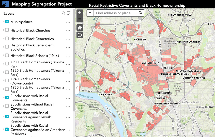
Mapping Segregation Project, Montgomery Planning, MD
The land purchased by Black families was then often sold to other Black families or divided by kin so that communities were created. These communities were segregated in most places during Jim Crow and throughout the years of community redevelopment in the 60s and 70s. The families grew most of their own food, such as corn, vegetables, fruit, poultry and hogs, and built their own churches, schools, lodge halls. Communities also had their own barbers, midwives, blacksmiths, builders and well-diggers. Some had their own post offices and general stores. Segregated communities were places of mutual caring and support, and were places of relative safety in a county defined by redlining and other forms of housing and racial discrimination. (Montgomery Planning 2022) (Afzal 2021)
Unattributed photos by Neile Whitney.
References
Buglass, Ralph D., and Sharon R. Duffin. 2023. “The Segregated Black Schools of Montgomery County, MD.” Montgomery History. https://montgomeryhistory.org/wp-content/uploads/2024/09/Segregated-Schools-of-Montgomery-County-rev.-2024.pdf
Green, Jerry (Kenneth), Jamie Tolliver, and Gladys Lyons. 2025. Panel on Brownstown, Historic Black Community in Germantown, MD. Germantown, MD: Germantown Historical Society.
Maryland Historical Trust. 2007. Brownstown Historic District. Maryland: n.p. https://mcatlas.org/filetransfer/HistoricPreservation/Cemeteries/065_Asbury_UM_Germantown/MHT_M-18-29_Brownstown.pdf
Montgomery Planning’s Historic Preservation Office. 2025. “Mapping Segregation Project: Racial Restrictive Covenants and Black Homeownership.” Wheaton, Maryland: The Maryland-National Capital Park and Planning Commission. https://mcplanning.maps.arcgis.com.
Seneca Community Church. 2020. “About Us.” https://senecachurch.org/aboutus.html.
United States Census. 1870. Schedule 1, Inhabitants of the 3rd District of Montgomery County, MD, Entry for William and Clarissa Brown. Maryland. https://www.familysearch.org/ark:/61903/1:1:MN3J-FLG?lang=en. (Familysearch requires a log-in, which is free.)
United States Census. 1880. Schedule 1, Inhabitants of the 3rd District of Montgomery County, MD, Entry for Moses and Harriet Hoes. https://www.familysearch.org/ark:/61903/1:1:MNQR-Z3J?lang=en. (Familysearch requires a log-in, which is free.)
United States Census. 1900. Schedule No. 1: Inhabitants, Darnestown District, Entry for Golden and Harriett Driver's family & neighbors. Maryland: n.p. https://www.familysearch.org/ark:/61903/3:1:S3HT-DH57-ZWX?view=index&personArk=%2Fark%3A%2F61903%2F1%3A1%3AM32Z-C5W&action=view&cc=1325221&lang=en&groupId=M92V-9VG. (Familysearch requires a log-in, which is free.)
United States Census. 1930. 1930 Population Schedule, Entry for Harry and Ruby Clipper family & neighbors. Maryland: n.p. https://www.familysearch.org/ark:/61903/3:1:33SQ-GRH3-4MM?view=index&personArk=%2Fark%3A%2F61903%2F1%3A1%3AX34G-DTH&action=view&cc=1810731&lang=en&groupId=. (Familysearch requires a log-in, which is free.)