
Bethesda
The Bethesda area here includes Chevy Chase, Cabin John, and Glen Echo. By the Civil War years, white families such as the Hodges, Perrys, Dunlops, and Poseys, enslaved between 12-42 persons each. Enslaved labor was used by these farms and manor homes, as well as taverns such as the Old Stone Tavern near Old Georgetown and Wisconsin Roads, the C&O Canal, stone quarries, and mills for flour, cider, and lumber.
After the Civil War, new hotels along the canal offered respite from the D.C. heat for visitors and provided work for local Black residents. In the 1890s, an electric trolley running from the new Glen Echo Park to Wisconsin Avenue, and the new B&O Railroad improved transportation to and from D.C. All of these businesses, as well as new suburban developments, provided employment for emancipated slaves from local plantations, as well as Virginia, North Carolina and even Mississippi. They lived on lanes like the ones in the image above, creating small communities with churches, schools and mutual aid societies.
Bethesda, MD
In the vicinity of Old Georgetown Road and Alta Vista Road northwest of Bethesda. In 1901 the Bethesda Land Company bought 222 acres and developed it. It was further subdivided later on to allow for homes for people of more limited financial means. It is likely that some of the residents of the Black Alta Vista community worked for the white families in this new suburb.
If anyone knows a more specific location or has information about founders and residents of this community, please let us know.

Alta Vista
Photo courtesy of the Maryland-National Capital Park and Planning Commission (M-NCPPC)
Brookmont
Bethesda, MD
Brookmont Park celebrates the small 1920s Brookmont neighborhood in Bethesda, which included three families. The community was located near Locks 6 and 7 in Bethesda, and community members quite possibly helped build and maintain these locks.
If anyone knows a more specific location or has information about founders and residents of this community, please let us know.

Photo of barge "Canal Clipper" between Fletcher's boathouse and Brookmont. Date not noted. Courtesy of Montgomery History.


Glen Echo Trolley line leading to Wisconsin Ave. in 1894. (Hopkins, Jr. 1894)
Carver Road
Cabin John, MD
As a ship-testing site, the U.S. Navy built the David Taylor Model Basin in Carderock in the late 1930s. In order to provide housing for its new employees, it built a white neighborhood of 100 homes, and a Black neighborhood with 25 homes. Initially, the Black families were required to pay rent, but many were sold to the residents after a few years. The community was linked to Gibson Grove. Between 1891 and 1935, residents may have traveled into D.C. using the streetcars/trolleys (see map) that ran from Glen Echo Park into Bethesda, and then down into D.C.
“By 1958, the Gibson Grove community consisted of 32 families on Carver and Seven Locks roads, including families descended from the original settlers, such as the Harrises, Joneses, and Jacksons.” (National Park Service and McMahon 2022, 189)
If anyone knows a more specific location or has information about the founders and residents of this community, please let us know.
Clipper Lane
Bethesda, MD
In the 1900 U.S. census, John and Martha Clipper, their six sons and two daughters, lived next to George Clipper (his son? 27 years apart in age) and George’s wife Lucy and their three children. The adult men were working as day laborers.
Apparently, the census takers had stopped listing an occupation for women...

Macedonia Baptist Church, Clipper Lane & River Road.

Dorsey Lane
Bethesda, MD
Dorsey Lane, once home of the Dorsey family, is now an industrial section of Bethesda.
If anyone knows a more specific location or has information about founders and residents of this community, please let us know.
Gibson Grove (originally called No. 10)
Bethesda, MD
Coming soon...

Photo courtesy of the Maryland-National Capital Park and Planning Commission (M-NCPPC).
Graysville / Elm Street
Bethesda, MD
Graysville was originally located on Elm Street in Bethesda. It was moved out of the center of Bethesda down to River Road, along what is now the Crescent Trail. George and Mary Kensilo, Martin and Elizabeth Turner, Victoria and Moses Smothers, and Mary and James Knowland were some of the residents noted in the 1880 census. The C&O Canal and African American Communities Historic Resources Study from 2022 tells us that some of the residents came from the nearby former Loughborough plantation on Little Falls Road. The C&O Canal study contains detailed information on many of these historic Black communities which were located near the canal. (National Park Service and McMahon 2022, 162)

Detail of Graysville in 1879 Hopkins Map, Bethesda Dist No. 7. (Needs complete citation)
Hawkins Lane
Jones Bridge Road
Chevy Chase, MD
Several homes on Jones Bridge Road, such as this yellow one, were built by family and friends of the Hawkins and were connected to the community around the corner.
Jones Bridge Road is linked to Hawkins Lane. James H. Hawkins had twelve children, and upon his death in 1928, the almost four acres were divided up among them. (The Ad Hoc Committee to Save Hawkins Lane and Snyderman, 1991, p. 5)
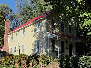
Home built in 1913.

Detail from the Master Plan for the Bethesda-Chevy Chase Planning Area, Montgomery County, MD, Parcel C16

Photo courtesy of the Maryland-National Capital Park and Planning Commission (M-NCPPC).
Miller’s Flats
Bethesda, MD
Miller’s Flats was a small residential neighborhood originally near what is now Bethesda Row. Black families here would have worked in the coal and lumber yards here. (Offutt 2009)
By the 1917 Deets & Maddox map of Bethesda, we see the B&O Railroad tracks (now the Capital Crescent Trail) crossing Wisconsin Avenue, which included the Georgetown Electric Railroad. Surrounding these are the flats built for Miller coal company employees. They stretched from close to today’s Hampden Lane down almost to...
River Road / Crow Hill
Bethesda, MD
The River Road / Crow Hill community was about where the McDonald’s is now, northwest of Little Falls Parkway. The Clipper Lane and Dorsey Lane kinship communities were down the road a little way and across the street.
Two acres of Crow Hill belonged to John Burley, formerly enslaved by B.T. Hodges, and two acres belonged to Nelson Wood. Harvey Matthews, Sr., interviewed for Bethesda Magazine in 2017, remembered being raised on a farm where the Whole Foods is now. (Roberts 2017) The church cemetery was across the street.

River Road School, circa 1930s. Archival photo courtesy of The Maryland-National Capital Park and Planning Commission (M-NCPPC)

Chevy Chase, MD
Driving up Hawkins Lane still gives a sense of what this small kinship community must have been like in the late 19th and early 20th centuries. Residents in the late 20th century fought off developers and had the lane designated as an official historic district. This kinship community was founded by James H. Hawkins in 1893, when he bought three acres of land...
Hawkins Lane, Chevy Chase, MD

C&O Canal Lock 6.
Rock Spring
Glen Echo Heights, MD
The Rock Spring Club was one of the hotels that grew up near the C&O Canal and employed local Black residents. In the 1900 U.S. Census, 47 year old Mariah Gray, born in North Carolina, is listed as working as a cook, and 40-year-old John W. Lewis, born in Maryland from parents originating in Maryland and Virginia, is a servant. Families living nearby included John and Alice Coates, and Mary and Robert Harrod. Black residents are listed as working in farming, as servants, in day labor, and other jobs.
Restrictive Covenants

MCPlanning Mapping Segregation Project interactive map.
As Bethesda developed in the early 1900s, former enslavers such as Peter Posey still owned 270 acres of land, R.H. Goldsborough 440 acres, and H. Loughborough 117 acres. Other swathes of land were being bought by developers like the West Chevy Chase Land Company, who added restrictive covenants not allowing Black or Jewish people to occupy homes there.
Uncredited photos by Neile Whitney, 2025.
References
Baist, George. 1904. “Baist’s Map of the Vicinity of Washington, D.C.” The Library of Congress. G. Wm. Baist. 1904. https://www.loc.gov/item/87691445
Deets, Edward H., and Charles J. Maddox. 1917. “A Real Estate Atlas of the Part of Montgomery County Adjacent to the District of Columbia.” https://Mchdr.montgomeryhistory.org. Montgomery History. 1917. https://hdl.handle.net/20.500.12366/455
Hopkins, Jr., Griffith Morgan. 1894. “The Vicinity of Washington, D.C.” Loc.gov. Griffith M. Hopkins. 1894. https://www.loc.gov/resource/g3850.ct003624/
Jones, Alexandra. 2009a. “Gibson Grove Gone but Not Forgotten: The Archaeology of an African American Church (Dissertation).” Www.mcatlas.org. Montgomery County Park and Planning. 2009. https://mcatlas.org/filetransfer/HistoricPreservation/Cemeteries/105_Moses-Hall_Cabin-John/105_Gibson-Grove_Church_Gone%20But%20Not%20Forgotten.pdf
———. 2009b. “Interviews with the African American Members of the Cabin John Community about Gibson Grove A.M.E. Zion Church and Moses Hall,” Interviews of Gibson Grove Descendants.” The Montgomery County History Digital Repository. Montgomery History. 2009. https://mchdr.montgomeryhistory.org/server/api/core/bitstreams/30233bde-474c-4c25-901d-51f45119d2dc/content
KCI Technologies, Inc. 1999. “Community Summary Sheet.” Https://Www.roads.maryland.gov. Maryland: Maryland Department of Transportation State Highway Administration. https://www.roads.maryland.gov/oppen/mont_co.pdf
Montgomery Planning (MD). 2026. “Mapping Segregation Project.” MC Planning Maps. https://mcplanning.maps.arcgis.com/apps/webappviewer/index.html?id=0d26456118d34a14b2d27aec8d6f2b1a
McMahon, Heather. 2022a. “Gibson Grove (Cabin John), Maryland (U.S. National Park Service).” Nps.gov. The National Park Service. 2022. https://www.nps.gov/articles/gibson-grove-cabin-john-maryland.htm
———. 2022b. “Historic Resources Study: African-American Communities along the Chesapeake & Ohio Canal.” National Park Service History. Washington, D.C.: National Park Service. https://npshistory.com/publications/choh/hrs-african-american-communities.pdf.
Offutt, William. 2009. “What’s in a Name?” Bethesda Magazine. Today Media. November 21, 2009. https://bethesdamagazine.com/2009/11/21/what-rsquos-in-a-name/
Roberts, Steve. 2017. “Uncovering the ‘Lost Colony’ in Bethesda.” Bethesda Magazine. Today Media. May 22, 2017. https://bethesdamagazine.com/2017/05/22/uncovering-the-lost-colony-in-bethesda/
Snyderman, Lois. 1991. “The Hawkins Lane Historic District Development Guidelines Handbook.” Montgomery Planning. Maryland: Montgomery Planning. https://montgomeryplanning.org/wp-content/uploads/2019/09/Hawkins-Lane-HD-Development-Guidelines-Handbook.pdf
The Historical Committee. 1989. “The ‘Little White Church on the Hill.’” Legacy of Gibson Grove. Gibson Grove Church. 1989. https://www.legacyofgibsongrove.com
Wallace, Glenn. 2018. “Montgomery County Cemetery Inventory Revisited: River Road Moses Cemetery.” Https://Mcatlas.org. Montgomery Preservation, Inc. 2018. https://mcatlas.org/filetransfer/HistoricPreservation/Cemeteries/327_River-Road-Moses_Bethesda/327_River-Road-Moses_Bethesda_2018/327_River-Road-Moses_Bethesda_2018_Survey.pdf
Whitley, L. Paige. 2017. “Uncovering the ‘Lost Colony’ in Bethesda.” Bethesda Today. Today Media. May 22, 2017. https://bethesdamagazine.com/2017/05/22/uncovering-the-lost-colony-in-bethesda/